Compass Rose Painting
Today, Ninety-Nines carry on the tradition and fulfill the need for airmarkings
by volunteering their time to paint the airport names,
compass rose symbols and other identifications on airports.
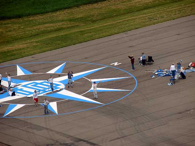
Compass roses are used at airports for swinging airplane compasses
(calibrating to current local magnetic variation and reducing compass errors.)

The Scioto Valley Chapter of the Ninety-Nines uses the basic design of the
compass rose prepared by the Air Marking Chairman of the North-Central Section of the 99s,
revised March, 1988, from a design made earlier by the Three Rivers Chapter.
The Scioto Valley Chapter modified the procedure of the layout,
but kept the design itself nearly unchanged.
We made some minor adjustments in the logo of the interlocking nines
for a more accurate rendition of the official logo,
and re-depicted the logo within a rectangular grid centered on the origin of the compass rose.
Also, we request the surveyor to mark magnetic directions every 30 degrees around the circle,
eliminating some difficult geometrical constructions that were required when only the North line was surveyed.
The Scioto Valley Chapter has used these procedures since 1990,
and has been quite successful in producing very striking compass roses at numerous airports
in central Ohio, New Mexico, and Colorado.
Here is a list of the Scioto Valley Compass Rose projects to date:
| Date |
Location |
Ident |
| September 15, 1990 |
Fayette County, OH |
I23 |
| September 7, 1991 |
Coshocton County, OH |
I40 |
| June 20, 1992 |
Union County, OH |
KMRT |
| July 15, 1995 |
Coshocton County, OH |
I40 |
| June 29, 1996 |
Holmes County, OH |
10G |
| September 27, 1997 |
Madison County, OH |
KUYF |
| June 5, 1999 |
Delaware Municipal, OH |
KDLZ |
| October 19, 2001 |
Raton Municipal, NM |
KRTN |
| September 25, 2002 |
Cañon City, CO |
KCNE |
| October 11, 2003 |
Greene County, OH |
I19 |
| June 5, 2004 |
Delaware Municipal, OH |
KDLZ |
| August 13, 2005 |
Darby Dan (Columbus), OH |
75OA |
| May 19, 2007 |
Delaware Municipal, OH |
KDLZ |
| October 28, 2007 |
Union County, OH |
KMRT |
| July 19, 2008 |
Delaware Municipal, OH |
KDLZ |
| May 12, 2012 |
Madison County, OH |
KUYF |
| October 13, 2012 |
Raton Municipal, NM |
KRTN |
| May 11, 2014 |
Delaware Municipal, OH |
KDLZ |
| May 7, 2017 |
Union County, OH |
KMRT |
Pictures and stories from several of these projects are in the Photo pages.
A few of the entries in the above list of "Locations" link to those project pages.
Compass-Rose Instructions
The following documents are in PDF (Portable Document Format),
and you may print copies of them if you wish.
The margin settings in the documents should be satisfactory for most printers using letter-size paper
when the page-scaling option is set to None
on your printer setup page.
If your printer cuts off some of the text, you may need to temporarily change the page-scaling option to:
Fit to Printable Area
(or similar option) on your printer setup page before sending the document to your printer.
After viewing these documents, use your browser's BACK button to return here.
Click here for a printable set of Compass-Rose instructions,
complete with diagrams.
Click here for a printable copy of the stencils.
The Scioto and Valley stencils should be printed on separate sheets of paper
and cut carefully with an X-Acto style of knife. You may need to print a current year
stencil.
The year page was created in Microsoft Word, using a landscape layout and minimum-allowable margins,
with the type-font of Stencil
at 325-point size, centered both horizontally and vertically.
If your computer does not have the TrueType Stencil font installed,
you may be able to locate a copy of STENCIL.TTF and place it into the Windows\Fonts folder
of your operating system.
How to Know When Your Compass Needs Adjustment
Compass Compensator Magnets
For airworthiness, the FAA requires that your magnetic compass must show no greater than
±10° error for any magnetic heading.
Aviation compasses are equipped with internal compensating magnets that can be adjusted to cancel out
compass disturbances for most of the residual magnetism of your aircraft’s iron and steel components,
such as engines, landing gear, hinges, and fasteners, thus improving the accuracy of your compass readings,
usually well within the FAA limits.
One of the compensating magnets, labeled N-S, trims error from the north- and south readings.
The other compensating magnet, labeled E-W, trims error from the east- and west readings.
Together, those two adjustments at right angles to each other
can approximately neutralize the local horizontal component of your residual airframe magnetization
oriented at any bearing angle relative to the longitudinal axis of the airplane.
Compass-Rose Check
With engine(s) running, battery fully charged, and avionics turned on,
align your airplane with a compass rose and record your compass readings for known magnetic headings
of North, South, East, and West.
Separately examine the two compass readings for your North and South headings,
and your other two compass readings for your East and West headings.
If both the North and South readings deviate to the same side
(i.e. either both a little westerly or both a little easterly),
then the north-seeking pole of your compass needle is being attracted slightly toward one wing or the other,
and the N-S compensator could reduce that error.
By similar reasoning, if both the East and West readings deviate to the same side
(i.e. either both a little northerly or both a little southerly),
then the north-seeking pole of your compass needle is being attracted slightly toward your airplane’s nose or tail,
and the E-W compensator could reduce that error.
Contact your aircraft or avionics maintenance technician to complete the compass compensation procedure.
Otherwise finish the full compass swing for readings every 30° around the circle,
and prepare an updated compass-calibration card, if needed.
Your gyroscopic Heading Indicator can be very useful throughout this process.
Set your H.I. accurately to the magnetic heading of your first alignment over the compass rose,
then use it to help you align your aircraft to all subsequent headings.
If your Heading Indicator is not equipped with automatic magnetic slaving,
you shouldn't use it as a precise reference for more than a few minutes between directional resets.
Earth's rotation alone is enough to cause a perfectly frictionless free-spinning gyroscope
to precess about 10° per hour at temperate-zone latitudes.
Misaligned Compass Roses
As the North Magnetic Pole migrates northwestwardly through the Canadian Arctic toward Russia,
distorting the worldwide geomagnetic-field pattern as it goes,
all compass roses in the contiguous United States gradually begin to point
further clockwise relative to the changing local magnetic north.
The rate this error accumulates can be as high as several tenths of a degree per year in some areas of the U.S.A.
Within a decade or so after a compass-rose creation, users may need to account for that pointing error
when swinging a compass over an outdated compass rose.
For example, if an old compass rose lagged 2° behind the current magnetic north direction,
swinging a perfectly compensated compass over that rose would appear to yield a compass-correction card
with +2° of error in all directions.
It would be necessary to subtract that constant 2° from all the entries on the compass-correction card.
That would then show properly how the compass reads relative to the actual geomagnetic field,
thus correcting for the clockwise alignment error of the outdated compass rose.
In short, swing a compass in the usual way over an old compass rose,
but subtract the pointing error of the compass rose from every correction value listed on the correction card.
A useful website for calculating historic values of compass variation (declination) at specific locations and dates
may be found at www.ngdc.noaa.gov/geomag-web.
What if my airport doesn't have a compass rose?
No compass rose? You still may have a chance.
Many airports now have at least one published straight-in instrument approach,
where the final approach course aligns perfectly with the runway centerline.
Assuming you have a non-slaved gyroscopic Heading Indicator
(formerly called a Directional Gyro),
carefully align your aircraft along the runway centerline and set your H.I.
to the current published value of the final approach course.
Then taxi clear of the runway and use your H.I. as magnetic-heading guidance
for at least the four cardinal-direction readings of your magnetic compass.
As mentioned above, though, beware of gyroscopic precession.
If your procedure takes longer than about 5–10 minutes,
you may need to return to the runway centerline
and reset your Heading Indicator instrument to correct for its inherent drift.


